
Wékpo:Arab league orthographic NED 50m.svg

Taille de cet aperçu PNG pour ce fichier SVG : Ɖiɖe ɔ sín gaɖiɖí: 550 × 550.
Djlɛ ɖévo lɛ: Ɖiɖe ɔ sín gaɖiɖí: 240 × 240 | Ɖiɖe ɔ sín gaɖiɖí: 480 × 480 | Ɖiɖe ɔ sín gaɖiɖí: 768 × 768 | Ɖiɖe ɔ sín gaɖiɖí: 1 024 × 1 024 | Ɖiɖe ɔ sín gaɖiɖí: 2 048 × 2 048.
Wémá dodo ɔ (Wépko SVG tɔn, bɔ gaɖiɖi tɔn nyi 550 × 550 pixels, bɔ kipkɛn tɔn nyi: 350 kio)
Kowun tɔn
| Xóɖɔdówú |
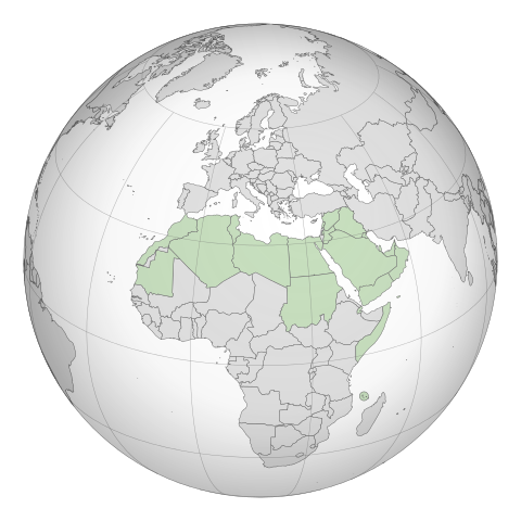
English: A map of the hemisphere showing the Arab League, centred on Libya. using an orthographic projection |
| Azǎn |
abɔxwísùn 2009 4 xwejísùn 2012 (last version uploaded) |
| Ɖoɖonu | Created using Grey-green orthographic projections maps and Gringer's Perl script with Natural Earth Data (1:50m resolution, simplified to 0.25px). |
| Wéwlǎntɔ | User:Lexicon (with modifications by others) and Reisio at en.wikipedia / Later version(s) were uploaded by Gringer at en.wikipedia. |
| SVG information | Le code de ce fichier SVG n'est pas valide en raison de 2 erreurs. |
Sɛn ée ɖo xo ɖo lé é nan zan gbɔn é wu é
| Cette œuvre a été placée dans le domaine public par son auteur, Reisio sur Wikipédia anglais. Ceci s’applique dans le monde entier. Dans certains pays, ceci peut ne pas être possible ; dans ce cas : Reisio accorde à toute personne le droit d’utiliser cette œuvre dans n’importe quel but, sans aucune condition, sauf celles requises par la loi. |
| Cette œuvre a été placée dans le domaine public par son auteur, Gringer sur Wikipédia anglais. Ceci s’applique dans le monde entier. Dans certains pays, ceci peut ne pas être possible ; dans ce cas : Gringer accorde à toute personne le droit d’utiliser cette œuvre dans n’importe quel but, sans aucune condition, sauf celles requises par la loi. |
Journal des téléversements d’origine
The original description page was here. All following user names refer to en.wikipedia.
- 2011-02-17 23:20 Gringer 550×550 (357596 bytes) using Natural earth data, easier to customise, recentred to Libya
- 2010-09-25 05:38 Reisio 550×550 (437253 bytes) {{Information |Description={{en|Arab_League_(orthographic_projection)}} |Source=[[Grey-green orthographic projections maps]] |Date=2009-11 |Author=[[:en:User:Lexicon|]] (with modifications by others) |Permission={{PD-self}} |other_versions= }}
.svg)
.svg)
.svg)
.svg)
.svg)
.svg)
.svg)
.svg)
.svg)
.svg)
.svg)
.svg)
.svg)
.svg)
.svg)
.svg)
.svg)
.svg)
.svg)
.svg)
.svg)
.svg)
.svg)
.svg)
.svg)
.svg)
.svg)
.svg)
.svg)
.svg)
.svg)
.svg)
.svg)
.svg)
.svg)
.svg)
.svg)
.svg)
.svg)
.svg)
.svg)
.svg)
.svg)
.svg)
.svg)
.svg)
.svg)
.svg)
.svg)
.svg)
.svg)
.svg)
.svg)
.svg)
.svg)
.svg)
.svg)
.svg)
.svg)
.svg)
.svg)
.svg)
.svg)
.svg)
.svg)
.svg)
.svg)
.svg)
.svg)
.svg)
.svg)
.svg)
.svg)
.svg)

.svg)

.svg)

.svg)
.svg)
.svg)
.svg)
.svg)
.svg)
.svg)


.svg)
.svg)
.svg)
.svg)
.svg)
.svg)
.svg)

.svg)
.svg)
.svg)
.svg)
.svg)
.svg)
.svg)
.svg)
.svg)
.svg)

.svg)
.svg)
.svg)
.svg)
.svg)
.svg)
.svg)
_without_national_boundaries.svg)
.svg)
.svg)
.svg)
.svg)
.svg)
.svg)

.svg)
.svg)
.png)
.svg)
.svg)
.svg)
.svg)

.svg)
.svg)
.svg)
.svg)
.svg)
.svg)
.svg)
.svg)
.svg)
.svg)
.svg)

.svg)
.svg)
.svg)
.svg)
.svg)
.svg)
.svg)
.svg)
.svg)

.svg)
.svg)

.svg)
.svg)
.svg)
.svg)
.svg)
.svg)
.svg)
.svg)
.svg)
.svg)
.svg)
.svg)
.svg)
.svg)
.svg)
.svg)
.svg)
.svg)
.svg)
.svg)
.svg)
.svg)
.svg)
.svg)
.svg)
.svg)
.svg)
_-_Crimea_disputed.svg)
.svg)
.svg)
.svg)
.svg)
.svg)
.svg)
.svg)
.svg)
.svg)
.svg)
.svg)
_political.svg)
.svg)
.svg)
.svg)
.svg)
_-_Crimea_disputed_-_no_borders.svg)
.svg)
.svg)
.svg)
.svg)
.svg)
.svg)
.svg)
.svg)
.svg)
.svg)
.svg)

.svg)
.svg)
.svg)

.png)
.svg)
.svg)
.svg)
.svg)
.svg)
.svg)
.svg)
.svg)
.svg)
.svg)
.svg)
.svg)
.svg)
.svg)
.svg)
.svg)
.svg)
.svg)
.svg)
.svg)
.svg)
.svg)
.svg)
.svg)
.svg)
.svg)
.svg)
.svg)
.svg)
.svg)
.svg)
.svg)
.svg)
.svg)
.png)
.svg)
.svg)
.svg)
_(orthographic_projection).png)
Ɖyɔ́ɖyɔ́ é bló ɖó wémá ɔ wu é
Zín azan alo gánmɛ ɔ bo nan do kpɔn wéma lé é ɖé ɖo gán énɛ mɛ é.
| Azǎn/Ganmɛ | Kówún tɔn | Aɖa tɔn lɛ | Nuzantɔ | Nɛ | |
|---|---|---|---|---|---|
| ɖin | 4 xwejísùn 2012 à 20:52 | | 550 × 550 (350 kio) | Domaina | Without South Sudan |
| 26 lìdósùn 2011 à 06:19 |  | 550 × 550 (349 kio) | OgreBot | (BOT): Reverting to the most recent version before uploads (originally uploaded on 2011-02-17 23:20 by Gringer). | |
| 26 lìdósùn 2011 à 06:19 |  | 550 × 550 (427 kio) | OgreBot | (BOT): This is the version originally uploaded on 2010-09-25 05:38 by Reisio; storing on commons for archival purposes | |
| 18 zofínkplɔ́sún 2011 à 00:24 |  | 550 × 550 (349 kio) | Gringer | {{Information |Description ={{en|1=A map of the hemisphere showing the Arab League, centred on Libya, using an orthographic projection and created using gringer's Perl script with [http://www.naturalearthd |
Wémá ɔ zizán
Nuwlanwlan ɖébu ɖo wékpo élɔ zan wɛ a
Wéma ɔ zizán tɔn
Wikis élɔ lɛ ɖo wékpo élɔ zan wɛ:
- Lě e nɔ zán bg.wikipedia.org gbɔn é
- Lě e nɔ zán fr.wikipedia.org gbɔn é